

The mountains and cliffs around Los Gigantes, Tenerife, offer spectacular hiking, with stunning views of the coast and Pico de Teide. One of the highlights is El Agujero, an awe-inspiring natural arch nestled in the cliffs 630+ meters above Los Gigantes. The trail to El Agujero, marked by its dramatic rock formations and the panoramic views it offers, promises an unforgettable experience for expert hikers able to navigate the steep and sometimes precarious terrain. This hike is a must-do for nature lovers and thrill-seekers alike, offering a unique blend of physical challenge and visual reward.
This post may contain affiliate links. If you make a purchase through these links, we will earn a small commission at no additional cost to you. We recommend products we have personally used or verified. Read the full disclosure here.
Don’t have time to read the whole article?
Here is the best Tenerife day tour!
Find the top Tenerife hotels!
Reserve your Tenerife rental car!
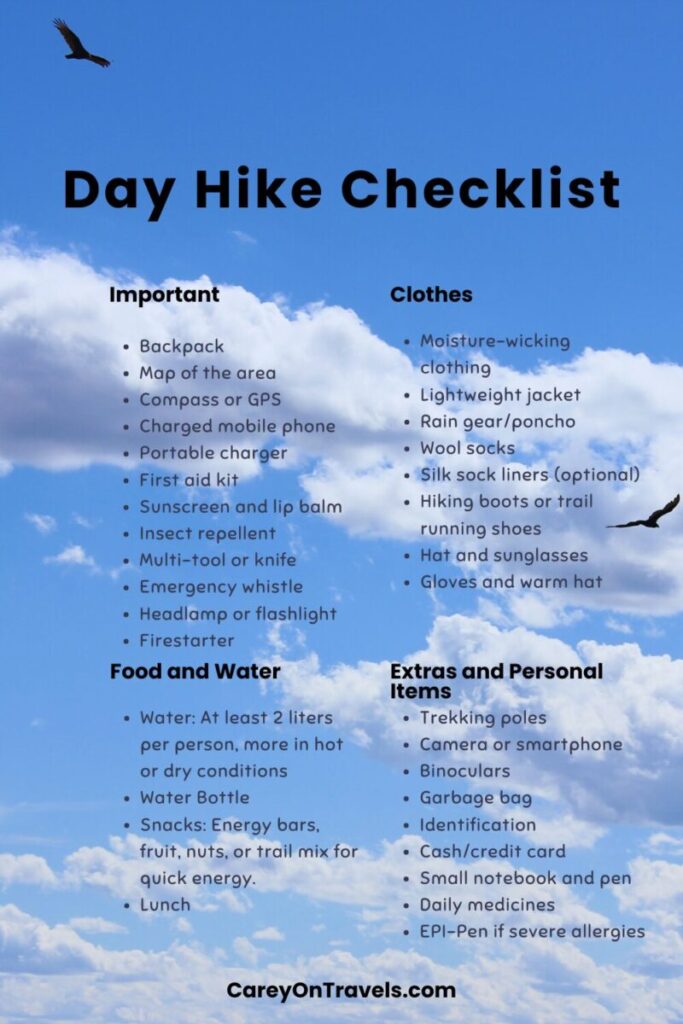
Don’t forget to bring along a day pack for hiking, a filtered water bottle, and a First aid kit!
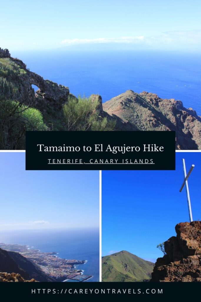
Hiking El Agujero via Cruz de Los Misioneros Details
- Distance: 5.7 miles (9.2 km) round trip
- Elevation gain: 1,833 ft (559 m)
- Average hiking time: 3-4 hours
- Difficulty level: Hard (recommended for expert hikers only)
- Parking: Tamaimo in town or near Iglesia de Santa Ana
- Public transport: Titsa bus lines
Before starting your hike, we recommend downloading the trail map on Alltrails, so that you have access when you are out of cell range. It is easy to get off the main path, so we referenced Alltrails fairly regularly on this hike. Make sure that you bring more than enough water and snacks with you. The trail is exposed to the sun for the majority of the hike.
Note that this trail is subject to closure due to habitat protection from February to August. Before heading to the trail, check for the latest status on https://www.tenerife.es/portalcabtfe/es/component/content/article/46-temas/medio-ambiente-de-tenerife/1035-teno.
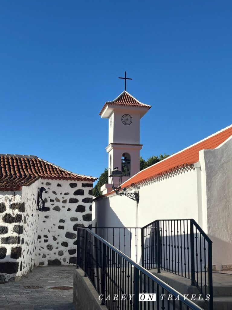
Tamaimo to Cruz de los Misionaros
If you’ve parked on the main road, follow Calle Santa Ana to the church (Iglesia de Santa Ana). Continue straight past the church onto Calle el Agua, passing some residential houses before you see the start of the trail.
Follow this trail past the Barranco de Santiago stream. You’ll then see signs for PR TF 65.2, Cruz de los Misioneros.
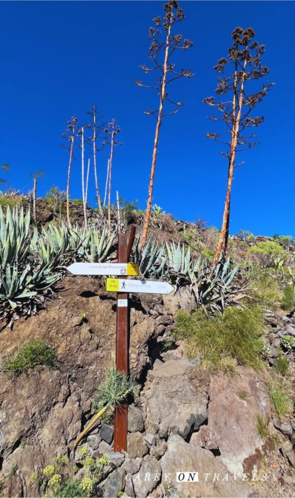
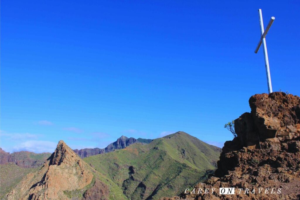
Follow a steep set of switch backs for 1.1 km, gaining 220 meters in elevation. You’ll reach a fork in the trail. Take the right fork to go to the Cruz de Los Misioneros viewpoint. This is a great spot for some photos and a break. Don’t forget to look east towards Pico de Teide in addition to enjoying the ocean views.
Cruz de Los Misioneros to Montaña Guama
After enjoying your break at Cruz de Los Misioneros, head back to where the trail split and continue straight on the PR-TF 65.3 El Molledo – Degollada del Roque trail towards Montaña Guama. There is one stretch that is a bit precarious, but there is a railing to hold onto. You’ll climb another 70 meters in elevation, reaching the summit of Montaña Guama.
Montaña Guama to El Agujero
At this point, you will head off of the signed trails, taking the trail west towards the water. This is where it becomes hard to follow. We enjoyed an easy gentle downhill for a while before checking our downloaded Alltrails map, realizing we had gone well past the turn-off. In order to not repeat our mistake, watch for a trail cutting off on the right, marked with red colored rocks. If possible, this is a great time to frequently check your downloaded map.
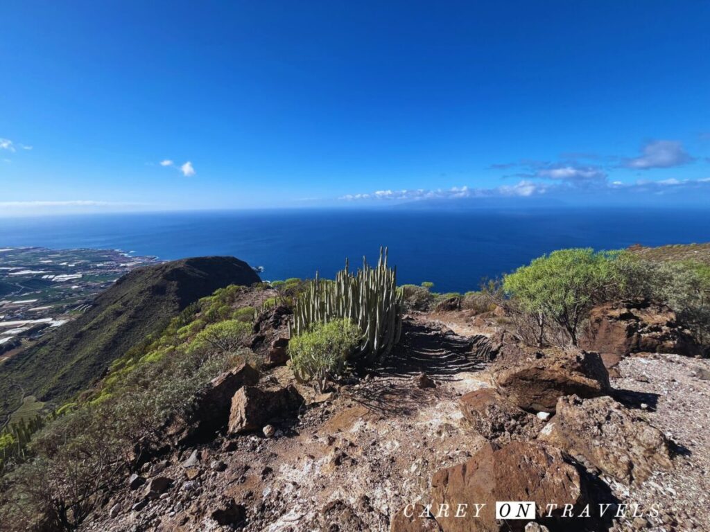
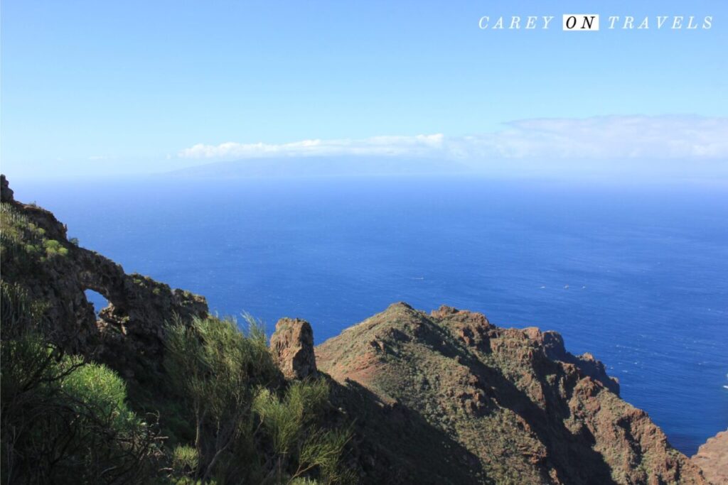
The trail rolls gently downhill until you reach the rock formation around El Agujero. Watch for a stone painted with a large yellow arrow, indicating the turnoff to El Agujero. Follow the path steeply downhill. The path here is narrow and has a steep drop-off into the ravine below. This needs to be done extremely cautiously. If you are not comfortable with this, you can sit on a rock and enjoy the view of El Agujero without climbing down the path and up into the hole (see the picture below).
El Agujero
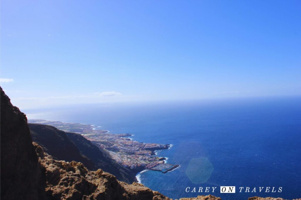
Climbing into El Agujero affords you with awe-inspiring views over Los Gigantes below. Take care when in the arch, due to the 630+ meter drop-off below. After enjoying the shade and views from El Agujero, head carefully back to the main trail.
Return to Tamaimo
You have a number of options for your return trip to Tamaimo.
- The loop found on Alltrails loops back via El Molledo. The trail is not marked well and is hard to follow. There are some precarious spots that you’ll need to be very careful on.
- Completing this as an out and back via Cruz de Los Missioneros is the most straight forward path back to Tamaimo.
Conclusion
Expert hikers have a unique opportunity to enjoy hiking from Tamaimo to El Agujero, a one of a kind destination nestled in the cliffs of Los Gigantes, Tenerife. Between the challenging navigation, the lack of shade, and the precarious drop-offs, this hike is certainly not for everyone. That said, this was our favorite hike of all of the ones we did in Tenerife, and would absolutely recommend it to those experienced enough to complete it.
This tour would be a great option if you’d prefer hiking in Los Gigantes, Tenerife area with a guide.
Planning a Tenerife trip? You may also like our post on:
- Epic Active Tenerife Itinerary
- Where to Stay in Tenerife: A Guide to the Island’s Best Stays
- Discovering Tenerife on Two Wheels: A Bike Tour Experience
Essential Hiking Tips
- Mountain weather: Always check the forecast before heading out and watch for rapid weather changes. When you see bad weather coming, get below timberline.
- Hydration and Fuel: Bring more water for your day hikes than you think you'll need. Electrolytes can help you stay hydrated (e.g., Nuun and LiquidIV). Don't drink water from streams and ponds, unless you are using a LifeStraw or similar. Pack energy-boosting snacks like nuts, fruits, and energy bars.
- Leave no Trace: Preserve the natural beauty by following the Leave No Trace principles. Pack out all trash, stay on designated trails, and avoid disturbing wildlife.
- Wildlife Awareness: Be aware of the wildlife in the area. Make noise while hiking to avoid surprising animals and know what to do in an encounter with local animals.
- Navigation: If you are using a map on your phone, make sure that it is downloaded. Cell service can be unreliable in the wilderness areas. Inform someone of your hiking plan and expected return time.
- First Aid: Carry a basic first aid kit for minor injuries. This should include, at minimum, Band-Aids, antiseptic, aspirin, mirror, matches, and a jack-knife, a whistle, flashlight, and multi-tool.
- Check our post on Day Hike Essentials for a more comprehensive list of items to bring on your day hike.
Travel Resources
We recommend booking through our preferred travel booking sites below.
| Air Travel | SkyScanner |
| Lodging | Booking.com, VRBO.com, Expedia.com, Hostelworld |
| Tours and Activities | Viator.com, GetYourGuide.com, TakeWalks.com, Tinggly.com |
| Car rentals | Discovercars.com |
| Travel insurance | Squaremouth |
| Bike and scooter rentals | BikeBookings.com |
| Train tickets | RailEurope |
| Bus tickets | Busbud |

[…] vibe, making it perfect for those looking to escape the hustle and bustle and access the many hikes the west coast has the offer. At sunset, the sky paints the water and cliffs in hues of gold and […]
[…] Los Gigantes Hiking: El Agujero […]
[…] seeking adventure, hiking to the top of the Los Gigantes cliffs offers a rewarding challenge. The El Agujere trail rewards hikers with panoramic views of Los Gigantes, the ocean, the cliffs, and the […]
I’ve seen Los Gigantes only from the side of the sea, during the whale watching excursion. We had a swim beneath those cliffs, and it looked amazing!
This gives me an idea of revisiting the site from the land side. I don’t like hiking during constant sun exposure, with no place to hide, but I’m sure the views are worth it!
I didn’t have a chance to swim beneath the cliffs (the beach was closed, and we opted for more hikes and bikes, missing out on the boat excursions).
[…] mins agoAdd comment Share this article FacebookXRedditPinterestEmail Next article Los Gigantes Tenerife Hiking: El Agujero Home » Blog » adventure » Tenerife or Madeira? A Traveler’s Guide to Two Paradise […]
[…] For a detailed description of this hike, see our El Agujero post. […]